ОКЕАНОЛОГИЯ, 2009, том 49, № 4, с. 586-603
МОРСКАЯ ГЕОЛОГИЯ
УДК 551.465
MODEL OF PALAEOENVIRONMENTAL EVOLUTION OF THE BLACK SEA REGION DURING THE LAST GLACIAL MAXIMUM - HOLOCENE
© 2009 Ivan Genov
Institute of Oceanology, Bulgarian Academy of Sciences, P. O. Box 152, 9000 Varna, Bulgaria
e-mail: idgenov@io-bas.bg Received January 21, 2008; in final form, June 25, 2008
Abstract - A model for the palaeoenvironmental evolution of the Black Sea and its adjacent basins during the past 20.000 years, in which variations in sedimentation, erosion, and hydrologic processes as a result of climatic change are taken into consideration, is developed. The data used include those from five cruises in the Black Sea with the participation of the author, seismo-acoustic data in the possession of the Institute of Oceanology in Varna, and data from the published literature. The most important result is that the water level of the Black Sea is controlled largely by that of the Marmara Sea via the Bosporus sill. The water circulation in the south part of the Bosporus channel as natural regulative mechanism of the Black Sea level during 11800-9000 yrs C14 BP is produced. A succession of climatic and water conditions for the Black Sea by pollen analysis is presented. The linear ridges on the Black Sea shelf as result of the lower Holocene regression are proved by means of a stratigraphic interpretation of the seismo-acoustic profiles. The levels of the Black Sea, Marmara Sea, and Mediterranean at regarded intervals of time are presented. An attempt at explanation of maximum number of facts from the study region with this model is made.
1. INTRODUCTION AND REGIONAL SETTING
During the last decade, a considerable amount of data was gathered which support the hypothesis of Ryan et al. [54] of rapid flooding of the Black Sea by saline Mediterranean waters. However, a number of questions on the details remain. Clear and successive explanation of all the fixed data from the study region for the past 20.000 years does not exist. In this paper, I shall construct a model for the palaeoenvironmental evolution of the Black Sea and its adjacent basins from the last glacial maximum to the present by critically reviewing the literature and presenting some new data. The primary objective is to investigate variations in sedimentation and erosion, as well as their dependence on hydrologic processes and water level during Neoeuxine-Holocene times.
The major scientific questions to be answered are:
—Why is the southern Bosporus sill situated in front of the Golden Horn Gulf (deeply in the channel)?
—What are the likely changes in sedimentation and erosion in the Bosporus Strait as a result of water level changes in the Black Sea, the Marmara Sea and the eastern Mediterranean during Neoeuxine-Holocene times and what role did the Bosporus sill play in these changes?
2. DATA AND MATERIAL
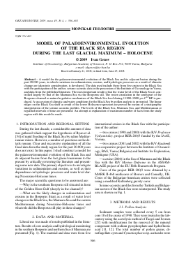
Liberal use was made of results published in the literature. Results of core analysis and hydrological monitoring in the southern Bosporus and northern Sea of Marmara are presented (Fig. 1). The material and data were from five
international cruises in the Black Sea with the participation of the author:
—two cruises (1998 and 2000) with the R/V Professor Vodyanitskiy, project RER 200/3 funded by the IAAE, Vienna,
—two cruises (2001 and 2002) with the R/V Akademik in a cooperative project between the Institute of Oceanol-ogy, BAS, Varna (Bulgaria) and Institute for Exploration, Mistiqoue (USA).
—a cruise (2004) in the Sea of Marmara and the Black Sea with the R/V Marion Dufresne in the ASSAM-BLAGE project of the EU Fifth Framework Program.
Cores of the project RER 200/3 were obtained by a MARK II-460 multicorer of Bowers and Connelly, UK. Cores of the Bulgarian-American cruises were collected using a modified Kullenberg gravity corer.
Seismo-acoustic profiles from the Turkish and Bulgarian sectors of the Black Sea were reinterpreted. The study area is shown on Fig. 1.
3. METHODS AND RESULTS
3.1. Pollen Analysis
Sediment samples were collected every 5 cm from core 18 of the cruise of 1998. They were treated in the laboratory using the acetolysis method of Faegri and Iversen [27] with modifications for the removal of the mineral component with sodium pyrophosphate and hydrofluoric acid [11, 12]. The total number of pollen grains, di-noflagellate cysts and Cymatiosphaera sp. acritarchs were
47°00/
46°00'
45°00/
<D g
o £
<D o3
•J
44°00/-
43°00'
42°00/-
27°00' 28°00/ 29°00/ 30°00/ 31°00' 32°00' 33°00' 34°00/
Longitude Eastern
27 28 29 30 31 32 33 34 31 36 37 38 39 40 41 42
34o40'34o45'34o50'34o55'35o00'35o05'34o10'35o15'35°20'
»29 Stations of the cruise by ^ RER/2/003 project (2000)
AB-1 g
■ Coring stations of the ^ cruise by Bulgarian- ^ American project (2001) ^
AB(II) P
■ Coring stations of the § cruise by Bulgarian-American project (2002) JR
-Seismic section - (sea fig. 4) 3
.....Seismic section (Line 7) ^
by Alpar, Gainanov, 2003- jP
(sea fig. 5) ^
> N HIM s in
3C • 26 p. 29 Jz
31 / / \ 27
y Í 2£
18 Miles
O
O
ffl
r o
■nrl >
r >
w
o
ffl
z <
o
s ffl
z
H >
r
M <
o r
c
H
o
z
o
•ti
H ffi
w dd
r >
n
m
w >
w
o o
Fig. 1. Area of the investigations.
Ltl 00 <1
counted. The Steppe-Forest Index (SFI) was also calculated and presented graphically:
SFI = (Chenopodiaceae + + Artemisia)/(Chenopodiaceae + Artemisia + AP).
(Here, AP is arboreal plants.) The SFI curve provides important information on the ecological conditions in the study area, while the dominant type of the dinoflagellate cysts reflects changes in the Black Sea basin [7]. The percentage composition of the pollen taxa was calculated on the basis of the pollen sum Ap + NAP (arboreal plus non-arboreal plants, excluding local components and di-noflagellate cysts), and pollen diagrams were constructed. The latter were divided into horizontal pollen assemblage zones (PAZ) [50] (Fig. 2).
The pollen diagram includes: AP (arboreal plants):
(a) trees: Pinus; Quercus, Ulmus, Tilia, Fraxinus excelsior type, Corylus; Carpinus betulus, Carpinus orientalis, Fagus, Alnus, Salix, Betula, Picea, Abies, Taxus, Juglans, Acer, Cornus
(b) shrubs: Juniperus, Rhamnus, Hippaphae, Ericaceae, Rhododendron, Humulus, Ephedra, Ro-saceae
NAP (non-arboreal plants):
herbs: Artemisia; Chenopodiaceae, Achillea-Asrer type, Taraxacum type, Cirsium type, Centaurea jacea type, Plantago langeolata; Polygonum aviculare; Ur-tica, Scleranthus; Cerealia type, Filipendula; Sanguisorba minor, Ranunculaceae, Adonis type, Lami-aceae, Centaurea depressa type, Trifolium, Apiaceae, Brassilty clayaceae, Caryophyllaceae, Centaurea sca-biosa type, Knautia, Boraginaceae, Fabaceae, Jurinea type, Galium type, Helianthemum, Linum, Liliaceae, Valeriana, Plantago maritima, Cyperaceae, Typha/ Sparganium type, Typha latifolia, Polypodiaceae, Myryophyllum, Potamogeton, Polygonum, Nymphaea Dinoflagellates: Lingulodinium machaerophorum, Spin-iferites ramosus, Spiniferites cruciformis, Tectatodium psilatum Acritarchs: Cymatiosphaera sp. Pollen assemblage zones (PAZ): PAZ I - (52-54 cm): The non-arboreal pollen prevails over the arboreal (66:34%). Characteristic for this zone is an increase in the steppe communities of herbs: Artemisia (40%), Chenopodiaceae (18%), Achillea, Aster. The pollen of tree species is represented mainly by Pinus (15%) and Quercus (14%). The pollen spectra in this zone are from the Neoeux-ine (Late Glacial) when the climate was dry and cold [7].
The dinoflagellate cysts of Tectatodium psilatum indicate low water salinity [7].
PAZ II - (0-52 cm): The arboreal pollen prevails in this zone over the non-arboreal (75:25%). Comparatively high is the participation of Quercus (27%), Corylus (11%), Carpinus (10%), Pinus (10%), Al-
nus, Fagus, Ulmus, Betula and Tilia. The pollen of herbs is represented mainly by Artemisia (15%) and Chenopodiaceae (4%). The pollen spectra in this zone are from the Holocene, when the climate was warm [7].
The dinoflagellate cysts from Lingulodinium machaerophorum, Spineferites ramosus and acritarchs Cymatiosphaera sp. are typical for waters with high salinity [7].
According to Atanassova, Bozilova [7], the spore-pollen spectra from marine sediments reflect changes in the terrestrial vegetation which are not synchronous with changes in the paleoecological conditions of the Black Sea, and the Late Glacial/Holocene boundary is placed at 10.300 yr BP. This age is generally accepted for continental deposits in Bulgaria [15].
Oscillations in the SFI curve can possibly be interpreted as due to climatic changes during the past more than 10.000 years.
3.2. Litho - and Biostratigraphic Analyses
Within the Holocene sediments of the Black Sea there is a lithologic boundary which marks the transition from freshwater (brackish) to saltwater deposits. For the deep basin, this boundary separates the lithologic unit 1c (lutite) from unit 1b (sapropelic mud) [51] and has an absolute age of about 7.000 C14 yr BP [43]. For the shelf and the upper part of the continental slope, this boundary is determined by mollusks too (C14 dating of Mytilus galoprovin-cialis yielded an age of also about 7.000 C14 yr BP [24]).
The Pleistocene/Holocene boundary which is also a climatic boundary is accepted to be around 10.000 C14 yr BP. This boundary in the Black Sea sediments is perceptible by means of pollen analyses (Fig. 2) called Neoeux-ine/Holocene boundary [36]. But the boundary about 7000 C14 yr BP in the Black Sea deposits is also marked by a change of stenohaline to euryhaline mollusks and by a contact of freshwater (brackish) sediments with sapropels. Hence the Black Sea was the freshwater (brackish) during the Early Holocene (10.000-7.000 C14 yr BP) as well as in Neoeuxine (Fig. 3; Fig. 2) [36, 56]. The Lower Holocene/Middle Holocene boundary is marked litho-logically by transition of unit 1c (lutite) to unit 1b (sapropelic mud) a
Для дальнейшего прочтения статьи необходимо приобрести полный текст. Статьи высылаются в формате PDF на указанную при оплате почту. Время доставки составляет менее 10 минут. Стоимость одной статьи — 150 рублей.