The maximal (pre-LGM and LGM) glaciation of south-east Iranian mountains exemplified by the Kuh-i-Jupar massif in Zagros
M. Kuhle
University of Göttingen, Germany
Статья поступила в редакцию 3 сентября 2006 г. Представлена членом редколлегии М.Г. Гросвальдом
Приводятся данные о двух горных оледенениях семиаридных гор Юго-Восточного Ирана — об их интенсивности, похолоданиях климата и снижении границы питания.
1. Introduction
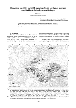
Detailed investigations as to the maximum Pleistocene glacier cover have been carried out in the 4135 m-high Kuh-i-Jupar massif at 29°40' to 30°15'N and 56°50' to 57°35'E over a period of nine months in 1973 and 1974 (Fig. 1, № 1). The results attained by
Quaternary-geological and geomorphological methods stand in contrast to the ideas developed so far with regard to the former glaciation of this semiarid section of Iranian mountains.
The Kuh-i-Jupar crest trending from W to E reaches a height of approx. 4000 m (3700—4135 m) over a
Fig. 1. Research areas in Central- and High Asia (Tibet and its surrounding mountains) visited by the author. The study presented here introduces observations on the Ice Age glacier cover from area № 1 in the Zagros mountains: 1 — 1973, 1974; 2 — 1976, 1977, 1995, 1998, 2000, 2002, 2005; 3 — 1981, 1998; 4 — 1982, 2003; 5 — 1984; 6 — 1986; 7 — 1987, 1992, 1995, 2000; 8 — 1988; 9 — 1988/89; 10 — 1989; 11, 12 —1991; 13 —1984, 1991; 14 — 1986, 1992; 15 — 1992; 16 — 1993; 17 — 1993, 1996; 18 — 1993, 2004; 19 — 1994; 20 — 1994/95, 2000; 21, 22 — 1995; 23 — 1996; 24 — 1997; 25 — 1998; 26 — 1999; 27 — 1999, 2000; 28, 29 — 2000; 30 — 2002; 31 — 2004; 32 — 2005 Рис. 1. Районы исследований автора в Центральной и Высокой Азии (Тибет и окружающие горы). Настоящая работа основана на наблюдениях за следами ледникового периода в районе № 1 (нагорье Загрос)
length of c. 20 km. It is drained by up to 12 km-long cross valleys. Between the outcropping edges and faces of the strata of Cretaceous limestones and Old-Tertiary conglomerates (Kerman conglomerate = ck) [6] with an incline of 20—35°, forming the highest summits, the valleys are set in with structural asymmetry. They show short, consistently steep curves of incline as well as bipartite inclinations. In the latter case — realized for instance in a 1450 m-high wall of the SW-slope — a steep escarpment at the valley head is continued by an only slightly inclined valley talweg (Fig. 2 on the left below No.2—6). A structural characteristic supporting the prehistoric glaciation, is the a good 10 km-long Kuh-i-Jupar NE-wall, the main part of which rises up to a height of over 3700 m (see Fig. 2 between № 1 and 14). The NE-exposition is most favourable to glacier development on the northern hemisphere.
The Kuh-i-Jupar receives 168 mm precipitation per annum in its foot area (Kerman-Station, 1650 m asl; 12 observation years), i.e. 100—170 mm [1, 3, 8, 22, 24]. In correspondence to the increasing altitude the mountain range itself may receive 200—500 mm/y (ibid.). The precipitation falls during winter. In the SW-adjacent Kuh-i-
Fig. 2. The sketch presents the course of the Kuh-i-Jupar crest (see Fig. 1) and a table of the summits. Only the highest mountain-summits are depicted Рис. 2. Схема хр. Кохи-Джупар c высочайшими вершинами
Lalezar massif (4374 m) the precipitation even reaches 250 mm/y more. In the middle of summer, stratus clouds can be observed coming from the SE, which derive from monsoonal di sturbances. They prove that the Kuh-i-Jupar is already situated in the southeastern border area of winter precipitation. Evidence of this is also provided by the heavy summer precipitation (July) which occurs in the Kuh-i-Hezar massif (4469 m) 30—40 km to the south, described by Stratil-Sauer ([26, p. 310; 27].
In January and February a 10 to 50 cm-thick snow cover is normal in the mountain foot areas between 1650 and 2000 m asl. In March 1974 the uniform snow cover still reached down to 2450 m. A continuous snow cover regularly persists more than one month above 2500 m and several months (between November and March) above 3000 m [14, Bd. I, p. 30/31; Bd. II, Abb. 98, 154). On the summits of the Kuh-i-Hezar (4469 m) and Lalezar (4380 m) several snow areas persist throughout the year. In the only somewhat lower Kuh-i-Jupar the winter snow completely apers out with the exception of an avalanche accumulation at the foot of the shadowy NE-wall (see above) at 3500 m [14, Bd. II, Abb. 124, 125].
The Station Kerman (1650 m) recorded -4 to -5°C average air temperature in December and January between 1950 and 1973. Here, in the lowest foot area, merely the period from May till August is completely free of frost. -12 to -14°C are reached every year; the lowest value of -30°C has been recorded in January 1973 [24]. From these data there can be extrapolated how much colder the arid-continental climate of the 2500 m higher mountain massifs is in winter. Even in the middle of summer freezing and thawing takes place on their summits nearly every day (for further details see [14, Bd. II, p. 27—33]). The average annual temperature in Kerman (1650 m) is 17.5°C.
2. The maximum extension of the Older Glaciation
(pre-LGM) (cf. [13, 14])
Two Ice Age glaciations can be evidenced by means of two extended front moraine stages (Fig. 3, 4). Both of
ice marginal ramps (IMP)
Cartography: A.FIemnitz Draft: M. Kuhle
Fig. 3. Schematic sketch of the northern Kuh-i-Jupar foreland with end moraines and ice marginal ramps (IMR) of the Older (pre-LGM) and Younger (LGM) glaciation (see also Fig. 4)
Рис. 3. Схематическая зарисовка северной части форланда массива Кохи-Джапар с конечными моренами и краевыми ледниковыми рампами (IMR) максимальных (до-LGM и KGM) оледенений
57'15'Е
2000 2500 3000 3500 4000m a.s.l.
Fig. 4. Moraines and ice marginal ramps (IMR) of the Würm (LGM) and Riss (pre-LGM) glaciations in the Kuh-i-Jupar (SE- Zagros, S of Kerman, Iran); see Figs.1, 2, 7. 1 — crest line, 2 — saddle, 3 — older moraines (pre-LGM), 4 — younger moraines (LGM), 5 — retreatal moraines, 6, 7 — moraines with ice marginal ramps (IMP), 8 — zone with push moraines (ground- and end moraines) Рис. 4. Морены и краевые ледниковые валы (IMR) вюрмско-го (LGM) и рисского (pre-LGM) оледенений в массиве Кохи-Джупар (юго-восточный Загрос, к югу от Кермана, Иран); см. рис. 1, 2, 7
them reach the mountain forelands of the Kuh-i-Jupar. On the N-slope their division into three older and two younger phases of advance becomes especially clear. Further recessional moraines can be recognized in the catchment area of the piedmont glaciation.
The Older Glaciation is documented by very large-scale front moraine bows which are decametres- to 110 m-high and 10 to 13 km-long (see Fig. 4). These
moraine ramps consist of boulder clay of a clayey-silty to clayey-sandy matrix into which polymictic, isolated boulders of biomicritic limestone and Kerman conglomerate are embedded, outcropping in the Kuh-i-Jupar. The largest boulders reach dimensions of c. 6*6*5 m [14, Bd. II, Abb. 33, 41]. They lie in the mountain foreland, 4.8 to 6.5 km away from the mountain foot, i.e. from the valley exit of the Darne Kanatkestan, on neogene sandstones and conglomerates which crop out in the underground as far down as 1900 m asl. Accordingly, in these positions the coarse boulders, forming the end moraine ramps, are erratic. The three old moraine ramps are cut through by meltwater paths in continuation of the mountain valleys (see Fig. 3+; Fig. 4 S of the Kanatkestan settlement). The flanks of these moraine valleys expose glacigenic push zones (e.g. Fig. 3+). These glaciotectonic tiltings can especially clearly be evidenced in glaciolimnic silts and clays - in part banded clays are concerned. During the first melt-back of the ice margin these warve clays have been sedimented by the oldest end moraine stages into one or several (?) simultaneous tongue basin lakes. Afterwards, during the renewed (second) advance of the Older glaciation, they have been overthrust by the ice margin. When the third glacier advance of the Older glaciation occurred, this order of events took place for the second time. Thereby the again deposited glaciolimnic clays have only been pushed together, but not large-scale overthrust.
The three end moraine ramps are followed by out-wash aprons (incline: 7 to 15°) [16, 18, 19]. In the farther piedmont area their material becomes more and more sorted and layered (Fig. 5). In the following text the whole form of a frontal moraine and an outwash apron is described as «Bortensander», i.e. ice marginal ramp (IMR). It is marked by the change from polymict coarse boulder material «swimming» chaotically and isolated in a fine material matrix to a well-sorted glaciofluvial, steeply accumulated gravel body (see Fig. 5).
Due to the fact that in relation to the glacier feeding
Ice Marginal Ramps (cross profile)
500 m
Fig. 5. Types of ice marginal ramps (IMR) representing two stages of development. Type B evolves from Type A and, being the
last stage, inevitably occurs more frequently. See Figs. 3, 4, 6 Рис. 5. Два типа краевых ледниковых рампов (IMR), представляющих две стадии развития. Тип B развивается из типа А и, будучи последней стадией, неизбежно встречается наиболее часто; см. рис. 3, 4, 6
(Bortensander =Ice Marginal Ramp =IMR) as a function of the glacier front steepness of an ice stream in steady state
Fig. 6. Despite a climate-controlled uplift of the ELA (snow line) the ice margin of the piedmont glacier in the northern foreland of the Kuh-i-Jupar remained in the same outline-position at the end moraine during the Older glaciation (pre-LGM) (see Figs. 4, 7a). However, the uplift of the ELA has caused the melting-down of the glacier surface. From this resulted a change of the angle of repose of the meltwater from steep (I) to flat (III). The oldest Phase I corresponds to Type A of the IMR in Fig. 5; Phases II and III to Type B in Fig. 5. Section 1 shows the left part of Type B
Для дальнейшего прочтения статьи необходимо приобрести полный текст. Статьи высылаются в формате PDF на указанную при оплате почту. Время доставки составляет менее 10 минут. Стоимость одной статьи — 150 рублей.